

"The Walnut Creek Watershed Council is a voluntary, non-regulatory stakeholder group that supports a healthy and sustainable Walnut Creek watershed."
Council Meets on the 1st Thursday of even months from 9:30am to 11:30am at the County Public Works Building on 255 Glacier Drive in Martinez
The Council hosts guest speakers that discuss topics relative to the stewardship of the Walnut Creek Watershed. Please Click the Button Below for more information about WCWC!
Arroyo del Cerro
Bolinger Creek
Dan Cook Canyon
Galindo Creek
Grayson Creek
Green Valley Creek
Grizzly Creek
Happy Valley Creek
Hidden Valley Creek
Indian Creek
Lafayette Creek
Lafayette Reservoir
Las Trampas Creek
Little Pine Creek
Murderer's Creek
Old Jonas Creek
Pacheco Creek
Pine Creek
Reliez Creek
San Catanio Creek
San Ramon Creek
Sans Crainte Creek
Sycamore Creek
Tice Creek
Vine Hill Creek
Walker Canyon
SIZE: Walnut Creek Watershed is the largest in Contra Costa County. At 93,556 acres (about 146 square miles) it occupies the central part of Contra Costa County, draining the Diablo Valley and the west side of Mount Diablo. The combined length of all creek channels (Walnut Creek, and its network of tributaries) is 310 miles. Walnut Creek flows northward emptying into Pacheco Slough and then into the San Francisco Estuary at Suisun Bay. In normal conditions, Walnut Creek flows at a rate of about 82 cubic feet of water per second, but in a major serious flood (a “100-year” flood) it would convey about 25,600 cubic feet of water per second past any given point.
CITIES: Danville, Lafayette, Pleasant Hill, and Walnut Creek lie completely within the watershed boundaries, while Concord, Martinez, Moraga and San Ramon are partly within Walnut Creek watershed.
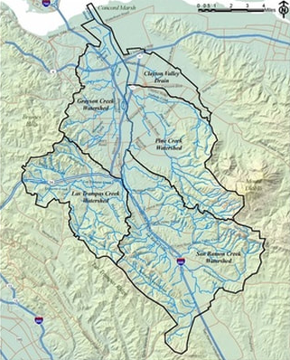
SUB-WATERSHEDS: Five major drainage basins direct water into Walnut Creek. These subwatersheds are named for their tributary creeks. The San Ramon Creek watershed drains the southeastern part of Walnut Creek Watershed, Las Trampas Creek watershed drains the Lafayette area, Grayson Creek watershed collects water from the Pleasant Hill area in the northwest, Pine Creek watershed drains the eastern area from Mt. Diablo and southern Concord, while a small un-named creek takes water from north Concord near Olivera Road and empties into Walnut Creek near Highway 4. At its mouth, Walnut Creek empties into Peyton Slough before entering the Bay.
SOME WATERSHED CHANGES THROUGH TIME:
Learn More: Explore or download the Contra Costa County Watershed Atlas to learn more about the geography of Walnut Creek Watershed and the other watersheds in Contra Costa County.
